
Context
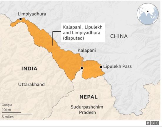
Nepal announced the printing of a new Nepalese Rupee 100 currency note featuring a map showing disputed territories: Lipulekh, Limpiyadhura, and Kalapani. India has objected to this depiction.
About
- Border Length: Nepal shares over 1,850 km of border with five Indian states: Uttarakhand, Uttar Pradesh, West Bengal, Bihar, and Sikkim.
- Kalapani: Kalapani is situated on the easternmost point of the Pithoragarh district in
- Northern boundary are shared by the Tibet Autonomous Region of China
- Eastern and southern borders are shared by Nepal.
- The area is situated between the trijunctions of Lipulekh, Limpiyadhura, and Kalapani, which connects China (Tibet) with Nepal-India.
- It is situated on the banks of the Kali River at an elevation of 3600 meters.
- The Kalapani regions are located along the eastern boundary between Nepal's Sudurpashchim Pradesh and the Indian state of Uttarakhand.
- Although Nepal claims the area for historical and geographical grounds, India currently controls it.
- Lipulekh Pass: Situated on the border between India's Uttarakhand and China's Tibetan autonomous region. Lipulekh pass has been used since ancient times by traders, pilgrims, and travelers between India and China, including those going to Kailas and Manasarovar.
- Limpiyadhura: This is where the territories of India, Nepal, and China meet.
Fact Box: Kali River
|


