

Published: 10th Feb, 2023
Context
Recently, the Joint project of National Aeronautics and Space Administration (NASA) and the Indian Space Research Organisation (ISRO), called NISAR, got a send-off ceremony at the American space agency’s Jet Propulsion Laboratory (JPL) in Southern California.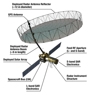
Background:
- NISAR has been built by space agencies of the US and India under a partnership agreementsigned in 2014.
- NISAR is expected to be launched in January 2024 from Satish Dhawan Space Centre into a near-polar orbit.
- The satellite will operate for a minimum of three years.
About NISAR:
- NISAR stands for NASA-ISRO Synthetic Aperture Radar.
- It is an Earth observation satellite.
- The 2,800 kilograms satellite consists of both L-band and S-band synthetic aperture radar (SAR) instruments, which makes it a dual-frequency imaging radar satellite.
- NASA has provided the L-band radar, GPS, a high-capacity solid-state recorderto store data, and a payload data subsystem.
- And the ISRO has provided the S-band radar, the GSLV launch systemand spacecraft.
- Another important component of the satellite is its large 39-foot stationary antenna reflector
- It is made of a gold-plated wire mesh, the reflector will be used to focus the radar signals emitted and received by the upward-facing feed on the instrument structure.
Additional features:
- By using synthetic aperture radar (SAR),NISAR will produce high-resolution images.
- SAR is capable of penetrating cloudsand can collect data day and night regardless of the weather conditions.
|
According to NASA, “the instrument’s imaging swath — the width of the strip of data collected along the length of the orbit track — is greater than 150 miles (240 kilometres), which allows it to image the entire Earth in 12 days. |
What is the mission?
- NISAR will observe subtle changes in Earth’s surfaces, helping researchers better understand the causes and consequences of such phenomena.
- It will spot warning signsof natural disasters, such as volcanic eruptions, earthquakes and landslides.
- The satellite will also;
- Measure groundwater levels,
- Track flow rates of glaciers and ice sheets, and
- Monitor the planet’s forestand agricultural regions, which can improve our understanding of carbon exchange.
- ISRO will use NISAR for a variety of purposes including agricultural mapping, and monitoring of glaciers in the Himalayas, landslide-prone areas and changes in the coastline.