

17th October 2023 (7 Topics)
2
Oct
3
Oct
4
Oct
5
Oct
6
Oct
7
Oct
9
Oct
10
Oct
11
Oct
12
Oct
13
Oct
14
Oct
16
Oct
17
Oct
18
Oct
19
Oct
20
Oct
21
Oct
23
Oct
24
Oct
25
Oct
26
Oct
27
Oct
28
Oct
30
Oct
31
Oct
Sinking Islands of India
Context:
The National Green Tribunal (NGT) has decided to issue notices to the Coastal Zone Management Authorities (CZMAs) in the coastal States and Union Territories asking it to consider including the recommendations made by an expert panel on the issue of dangers of sea level rise and submergence of low-lying lands into the Integrated Island Management Plans (IIMPs).
About
- NGT asks coastal zone authorities to integrate expert panel recommendations into island management plans.
- The Principal Bench of the tribunal issued an order stating that the suggestions incorporated in the panel report need to be looked into for preparation/amendment of the IIMPs.
- The committee had recommended island-specific sustainable development and tourism policy keeping the climate risks in mind.
Why are some islands in India sinking?
- India has a fragile network of over 1,382 islands.
- However, several of these islands are under threat due to unseasonal cyclonic storms, sea erosion and new development projects.
- One such island in Lakshadweep has entirely disappeared from the map.
- So, let us take a look at islands across the country that are under threat:
- Lakshadweep
-
- Lakshadweep has a land area of just 32 sq.km. And a population of 70,000.
- Lakshadweep lagoons cover an area of 4,200 sq.kms.
- A group of scientists in 2021 urged the Central govt. to rethink the water villa project steered by NITI Aayog. They feared it would destroy the lagoons.
- Coastal constructions and unseasonal cyclones are causing soil erosion.
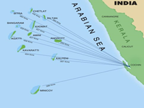
|
According to a study, waters surrounding the archipelago are expected to rise by 0.78 mm each year in the 2080-2100 period. Smaller islands may therefore experience loss of land along the coast. |
- Vaan island
- Vaan Island is located 6 kms from Thoothukudi coast, Tamil Nadu.
- This island in the Gulf of Mannar almost vanished from the map, about a decade ago.
- A team of underwater researchers have been working in the Gulf of Mannar for 25 years to reverse the damage caused by large scale coral mining till the 1990s.
- In 2013, Vaan Island split into two. The northern part submerged as the waves hit the islet directly in the absence of corals, causing rapid erosion.

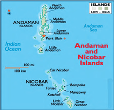
- Andaman and Nicobar islands
-
- The light house at Indira Point in the Andaman and Nicobar islands sank about four metres during the tsunami of 2004.
- In the Nicobar Islands, 97% of the mangrove cover was lost.
- The region witnessed over 450 earthquakes in the last 10 years.
- The sea level rise here is estimated to be 5mm per year, way higher than the global average.
- Ghoramara
-
- Ghoramara is located at the southernmost part of West Bengal.
- The tall palm trees on the edge of the island struggle to hold on to the depleting soil.
- One of the sources of income in this island was betel leaf cultivation.
- Before cyclone Yaas in 2021, there were about 550 units of betel leaf plantations.
- Majuli island
-
- Majuli is in Assam, India’s first island district.
- Its current geographical area is 483 sq. kms. But Majuli used to be 1,250 sq. km. before 1950.
- Reasons for this reduction: riverine erosion and embankments on the southern bank of the Brahmaputra.
- Paddy and mustard cultivation has suffered and so has fishing that was once a major source of income for many in Majuli.
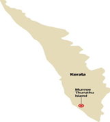
- Munroe Thuruthu
- Munroe Thuruthu Island in Kerala is witnessing steady deterioration.
- The island is ravaged by constant tidal flooding and ground subsidence. The once-fertile island now resembles a saline swamp and agriculture is nearly impossible.
- The researchers say that the lack of freshwater, sediment from the Kallada River, and the presence of several saline pools have been affecting both soil fertility and groundwater quality.
More Articles