
26th December 2024 (13 Topics)
Context
December 26, 2004 marks the 20th year since the 2004 Indian Ocean earthquake and tsunami. The 2004 Indian Ocean earthquake and tsunami was a turning point in our understanding of tsunamis and earthquake risks. It led to significant advancements in early warning systems, scientific research, and disaster preparedness.
What Happened on December 26, 2004 (brief background)?
- On December 26, 2004, a massive earthquake of magnitude 1 occurred off the coast of Sumatra, Indonesia.
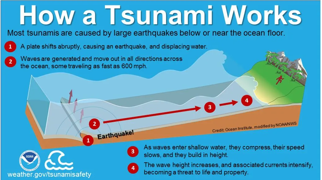
- This earthquake triggered one of the deadliest tsunamis in history, causing widespread destruction across 17 countries bordering the Indian Ocean. The tsunami killed around 227,000 people and displaced 1.7 million more.
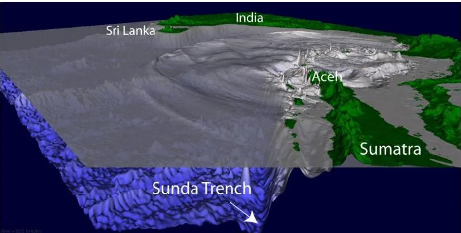
- Tectonic Background: The earthquake occurred in the Sunda Trench, where the Indo-Australian plate is being forced beneath the Burma microplate (part of the larger Eurasian plate).
- The earthquake involved the rupture of a 1,300 km long fault, starting from Sumatra in the south to the Coco Islands in the north.
- The tsunami was triggered by the longest faultline rupture from an earthquake ever observed, seconds before 7.59 am on December 26, 2004.
- The gap between the India plate and the Burma microplate was at least 1,200 kilometres (750 miles) long.
- It produced huge waves that were over 30 metres (100 feet) high, delivering energy equal to 23,000 Hiroshima atomic bombs and wreaking havoc.
- Indonesia is a vast archipelago nation on the Pacific “Ring of Fire,” which is a region of high seismic activity that stretches across the Pacific basin from Japan through Southeast Asia.
- Impact of the Tsunami:
- The tsunami waves traveled across the Indian Ocean, affecting countries like Indonesia, India, Sri Lanka, Thailand, Malaysia, the Maldives, and more.
- Some places, such as the Andaman and Nicobar Islands, saw 90% of the population wiped out. The disaster caused immense loss of life and property, especially in coastal regions.
- The tsunami generated by this earthquake was unprecedented in size. Scientists had not anticipated such a massive event in this region.
- Prior to this, there had been only two recorded tsunamis in the region (1881 and 1883), which were much smaller.

Two Decades of Change: Lessons Learned
- Global coordination: By 2005, the Intergovernmental Oceanographic Commission of UNESCO had been tasked with coordinating a worldwide tsunami mitigation strategy. Central to this effort was the creation of the Indian Ocean Tsunami Warning and Mitigation System (IOTWMS) — a network of organisations designed to monitor and alert countries at risk.
- Today, India, Indonesia, and Australia serve as the nerve centers for tsunami warnings across 26 nations in the Indian Ocean.
- Tsunami Early Warning Systems: In the aftermath of the 2004 disaster, significant steps were taken to improve tsunami preparedness. One of the key developments was the establishment of the Indian Tsunami Early Warning Centre (ITEWC) in 2007, under the Ministry of Earth Sciences. This centre operates advanced systems to monitor earthquakes and tsunamis 24/7.
- ITEWC is a designated Tsunami Service Provider (TSP)for the Indian Ocean region under UNESCO’s Intergovernmental Oceanographic Commission (IOC).
- The ITEWC uses seismological stations, pressure recorders, and tidal stations placed across the Indian Ocean.
- These devices can detect a tsunami-producing earthquake and issue warnings within about 10 minutes of detection. This system helps protect countries bordering the Indian Ocean from future tsunamis.
- The Indian National Centre for Ocean Information Services (INCOIS), based in Hyderabad, has been at the forefront of ocean-related research and services in India. INCOIS provides tsunami alerts to 28 countries, showcasing its technological and scientific expertise.
- INCOIS operates a network of more than 300 seismic stations spread across the Indian Ocean, using advanced Global Seismic Network (GSN) technology.
- These stations can detect earthquakes as small as magnitudes are analysed to assess tsunami potential.
- Scientific Advancements: The 2004 tsunami spurred research into tsunami geology and earthquake monitoring. This research uncovered important historical evidence of past tsunamis in the region, including evidence of a tsunami from a thousand years ago found in the Andaman and Nicobar Islands.
- Tsunami Geology: Scientists found ancient evidence, like dead roots of trees exposed by rising and falling tides, which helped date past tsunami events.
- GPS and Seismology: Research institutions have strengthened seismic observations and geodetic studies along coastal regions, including the Andaman Islands. These advances improve our understanding of tsunami risks.
- Deep-ocean Assessment and Reporting of Tsunamis (DART): A network of DART is strategically deployed to monitor minute changes in sea level caused by underwater seismic activity. These buoys relay real-time data to ITEWC via satellite communication. The latest versions of DART buoys are more durable and equipped with advanced sensors for greater accuracy. Besides, supporting systems such as bottom pressure recorders and tide gauges, help track tsunami propagation.
- Numerical modelling: Numerical Modelling recreates tsunami scenarios using equations in mathematics and physics. A tsunami or tsunamigenic earthquake can happen due to several different permutations and combinations of seismic parameters. These are simulated as pre-run scenarios and stored in electronic formats.
- Future Tsunami Risks: Although the 2004 earthquake was a huge event, researchers warn that other regions, like the Makran Coast (off the coast of Iran and Pakistan), still pose risks. These regions could generate tsunamis that might affect India’s west coast, including cities like Mumbai, which has nuclear power plants.
What measures are required?
The world has witnessed a tenfold increase in the number of natural disasters since the 1960s. Data captured between 1900 and 2019 by the Institute for Economics and Peace reveal an increase from 39 incidents in 1960 to 396 in 2019. Given the increasing number of such events, following measures can be adopted:
- Nature-based solutions: These solutions involve protecting, restoring, and sustainably managing ecosystems in ways that increase their resiliency and ability to address those societal challenges, while also safeguarding biodiversity and improving human wellbeing.
- For example: Mangrove forests along coastlines are not only important for sustaining fisheries but also for providing protective natural barriers against erosion and strong storms.
- Better disaster response: The Wayanad landslide has exposed significant lapses in intergovernmental coordination and communication. The lack of timely warnings and efficient evacuation plans contributed to the high death toll and widespread destruction. This points to a critical need for robust and streamlined communication channels between different government agencies and with the public to ensure timely and effective disaster response.
- Investment: There is need to invest in disaster risk reduction, improve communication and preparedness strategies, and hold accountable those responsible for insufficient safeguards.
Fact Box: Tsunami
|
PYQQ: The 2004 Tsunami made people realize that mangroves can serve as a reliable safety hedge against coastal calamities. How do mangroves function as a safety hedge? (UPSC 2011)
Solution: (d) |


