

29th April 2025 (12 Topics)
29th April 2025
Mains Issues
Context
The Vietnam War (1955–1975) was not only a humanitarian disaster but also a massive environmental catastrophe. Even 50 years after the war ended, Vietnam’s ecosystems still bear the consequences of military operations that involved chemical defoliation, forest burning, and land clearing.
How was the Environment Weaponized?
- Agent Orange: The U.S. military sprayed over 75 million liters of herbicides (including Agent Orange) across 6.4 million acres to strip forests and destroy crops.
- Agent Orange was a chemical herbicide and defoliant used by the U.S. military during the Vietnam War (1961–1971).
- It was part of a broader chemical warfare program known as Operation Ranch Hand.
- Composition: Agent Orange is a mixture of two herbicides:
- 2,4-D (2,4-dichlorophenoxyacetic acid)
- 2,4,5-T (2,4,5-trichlorophenoxyacetic acid)
- It was contaminated with TCDD (2,3,7,8-tetrachlorodibenzo-p-dioxin) — an extremely toxic dioxin compound.
- Use of Incendiary Weapons and Machinery
- Weapons like napalm bombs and “Rome Plows” (armored bulldozers) destroyed vast areas, scorching soil to infertility.
- Daisy Cutter bombs created large concussive impacts, killing entire ecosystems within a 900-meter radius.
- These actions left landscapes vulnerable to invasive grasses and loss of biodiversity.
- Weather Modification as a War Tactic
- Project Popeye (1967–1972): U.S. tried to extend the monsoon season by cloud seeding with silver iodide to disrupt North Vietnamese supply lines.
- This raised ethical and legal concerns about climate warfare, leading to a global treaty in 1978 banning weather modification for military use.
- Although the Geneva Conventions (1977 protocol) and ENMOD Treaty (1978) prohibit environmental destruction during war, enforcement is weak.
The Lasting Damage
Even after 50 years, Vietnam’s environment is still suffering:
- Destroyed Mangrove Forests: Vital coastal ecosystems were wiped out, affecting fish populations and livelihoods.
- Loss of Biodiversity: Many areas that were chemically defoliated never fully recovered. Entire species of birds, mammals, and plants disappeared.
- Contaminated Soil and Water: Dioxin from Agent Orange has remained in the soil and food chain, leading to ongoing health problems for both humans and animals.
Fact Box: Concept of Ecocide
|


Mains Issues
Context
The Stockholm International Peace Research Institute (SIPRI) released its Trends in World Military Expenditure 2024 report, highlighting the global military spending landscape, with a focus on the increase in military budgets due to geopolitical tensions, ongoing conflicts, and modernization programs.
Key Highlights from the Report
- India vs. Pakistan Military Spending (2024):
- India's military expenditure reached USD 86.1 billion, representing the 5th largest globally, marking a 6% increase from the previous year.
- Pakistan's military expenditure was much lower at USD 10.2 billion, making it almost nine times less than India's spending.
- This stark contrast in military spending underscores the growing strategic imbalance between the two nuclear-armed neighbors.
- Global Military Expenditure:
- The top five military spenders in the world—United States, China, Russia, Germany, and India—accounted for 60% of total global military spending, totaling USD 1,635 billion.
- China's spending increased by 7% to USD 314 billion, reflecting continued military modernization and expansion of its nuclear and cyber capabilities.
- Russia's military spending surged by 38% to USD 149 billion, driven largely by its ongoing war in Ukraine.
- Germany's military spending jumped by 28% to USD 88.5 billion, marking it as the 4th largest spender
- Europe's Rising Military Spending:
- Europe's military expenditure rose 17% in 2024, driven largely by the war in Ukraine. European military spending has now surpassed Cold War levels.
- Germany, as the largest spender in Europe, has significantly increased its budget, signaling its commitment to NATO and regional defense.
- Other European nations like Poland saw 31% growth, with military spending reaching USD 38 billion (4.2% of its GDP).
- Ukraine's Military Burden:
- Ukraine's military expenditure grew by 9% to USD 64.7 billion in 2024, making up 43% of Russia's military budget. It has the highest military burden, with military expenditure accounting for 34% of its GDP.
- Ukraine’s military spending is disproportionately high due to the ongoing conflict with Russia, with the country reportedly spending nearly all of its tax revenue on defense.
- Global Military Trends:
- The overall increase in global military spending in 2024 was largely driven by the war in Ukraine, NATO's defense initiatives, and the ongoing arms race in Asia.
- Russia’s military spending increase was a response to its conflict with Ukraine, and China continues to modernize its forces, including its naval and cyber capabilities.
- Military expenditures in central and eastern Europe saw substantial increases, with Poland and Germany among the biggest contributors to the rise in European defense budgets.
About SIPRI
|


Prelims Articles
Context
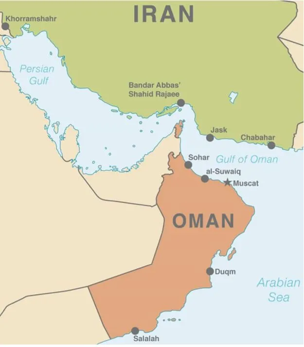
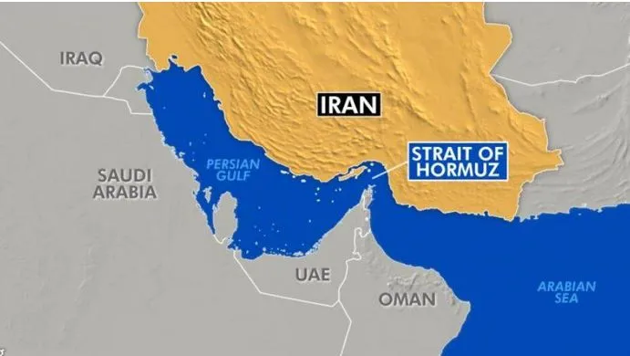
Shahid Rajaee Port, Iran's largest port and the main hub for the country’s international maritime trade, located in southern Hormozgan province, was rocked by a massive explosion, resulting in nearly 700 casualties.
About
- Shahid Rajaee Port is situated on the northern shore of the Strait of Hormuz, a global chokepoint for 20 percent of the world’s oil trade, or in the narrower sense, on the Khuran (Clarence) Strait that separates the Iranian island of Qeshm from the mainland.
- Administratively, it is part of Bandar Abbas County in Hormozgan Province, about eight kilometers west of the city limits of Bandar Abbas.
- It is one of two cargo and five city ports, located between Shahid Bahonar Port to the east and the Iran Shipbuilding & Offshore Industries Complex to the west.
- Hormozgan province has 32 active ports, including Shahid Bahonar, Jask, Lengeh, Tiab, Aftab, and Kish, which act as backups to Shahid Rajaee.
- One of the two coastal branches of the national railway network connects it to the country's main industrial provinces, while the other leads to Khuzestan province in the north of the Persian Gulf.
- Its geographical location at the closest point to the Strait of Hormuz and the entrance to the Persian Gulf is considered the most important import and export gateway of Iran due to its short distance from the main intercontinental shipping route.
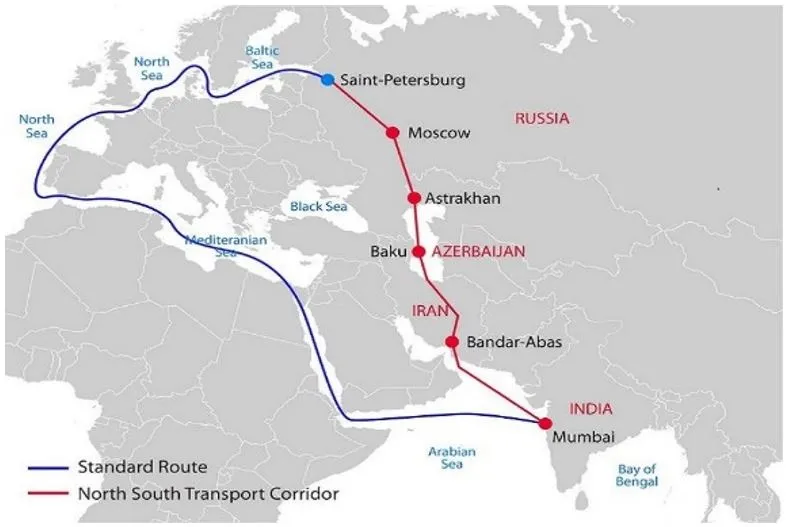
- The port also lies on the International North-South Transport Corridor (INSTC), connecting the Indian Ocean and Persian Gulf to the Caspian Sea, Russia, and Northern Europe.
- This position facilitates trade and transit between Asia, Africa, and Europe, making it a vital hub for regional connectivity.
- The port is also a Special Economic Zone (SEZ).
Fact-Box: Other Key-LocationsStrait of Hormuz
 |
PYQQ-Consider the following pairs: (2019)
Which of the pairs given above are correctly matched?
Solution: (b) Q- Consider the following pairs: (2018)
Which of the pairs given above are correctly matched?
Solution: (b) |


Prelims Articles
Context
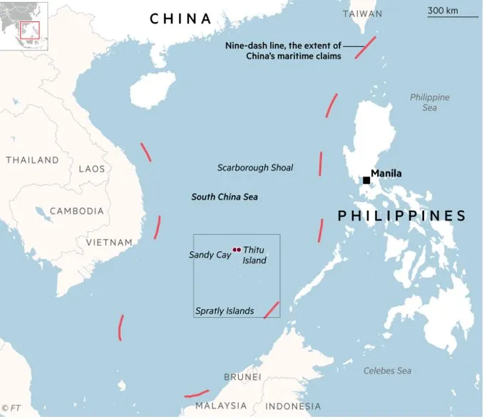
China and the Philippines defended their claims to a disputed reef in the South China Sea, after Manila accused Beijing of seeking to “intimidate and harass” with a state media report that suggested the area had been seized.
About the disputed Reef
- The Sandy Cay reef lies near Thitu Island, or Pag-asa, where the Philippines stations troops and maintains a coast guard monitoring base.
- The reef is part of the Spratly Islands.
- It is just a sand bank measuring little more than 200 square metres.
- Sandy Cay has strategic value for China because international law grants it a territorial sea.
- That 12-nautical-mile radius overlaps with Thitu Island, the South China Sea reef the Philippines uses to track Chinese moves in the area.
Fact Box: What is the South China Sea Dispute?
|
PYQQ. Which one of the following statements best reflects the issue with Senkaku Islands, sometimes mentioned in the news? (2022)
Solution: (b) |

Prelims Articles
Context
Prime Minister Narendra Modi, during his ‘Mann Ki Baat’ address, urged people to use the ‘Sachet’ mobile app, launched by the National Disaster Management Authority (NDMA), which helps in getting a headstart on escaping natural disasters.
What is the ‘Sachet’ app?
- The Sachet mobile application provides real-time geo-tagged early warning alertsof disasters.
- Key-features:
- It functions on common alert based protocol (CAP) and provides information based on current location. Users can subscribe to any state/district in India to receive alert notifications.
- CAP is an international standard format for emergency alerts, designed to ensure that warnings can be consistently structured and disseminated across various platforms and technologies, enhancing interoperability.
- Sachet will alert users in case of “flood, cyclone, land-slide, tsunami, forest fire, avalanche, storm, hurricane or lightning”.
- Furthermore, the app also provides weather reports and forecasts from Indian Meteorological Department (IMD) for day to day weather updates.
- The app can be operated across 12 Indian languages
- It also provides various useful resources such as Dos & Don'ts, helpline numbers, alert affected area and satellite receiver connectivity feature.
- It functions on common alert based protocol (CAP) and provides information based on current location. Users can subscribe to any state/district in India to receive alert notifications.
- Implementing Agency: The Centre for Development of Telematics (C-DOT), the Government of India’s Research & Development Telecom Technology Centre, serves as the pan-India implementation partner for Phase 1 of the Sachet project.
India’s Vulnerability to Natural Disasters
|

Prelims Articles
Context
India’s industrial activity continued its recovery momentum with the Index of Industrial Production (IIP) growing 3 per cent year-on-year in March 2025, according to data released by the Ministry of Statistics and Programme Implementation.
March 2025 IIP Performance
- Industrial output grew by 3% year-on-year in March 2025.
- This was below market expectations (3.3%) but an improvement over February’s 2.7% (which was a six-month low).
|
Sector-wise Performance |
||
|
Sector |
March Growth |
February (Revised) |
|
Manufacturing |
3.0% |
2.8% |
|
Mining |
0.4% |
1.6% |
|
Electricity |
6.3% |
3.6% |
|
So, while electricity generation was strong (likely due to increased demand), mining slowed significantly, pulling down the overall number. |
||
- Consumer Durables (like appliances, vehicles): Grew 6.6% in March, up from 3.7% in February – suggests rising household demand, possibly due to festival-season spillover or improving rural sentiments.
- Capital Goods (like industrial machinery, tools): Slowed to 2.4%, from a strong 8.2% previously – a sign that private sector investment is still cautious, possibly due to global uncertainties and trade issues.
Fact Box: Industrial Output
|
PYQQ. In India the overall Index of Industrial Production, the Indices of Eighth Core Industries have combined weight of 37.90%. Which of the following are among those Eight Core Industries? (2012)
Select the correct answer using the codes given below:
Solution: (c) Q. In the ‘Index of Eight Core Industries’, which one of the following is given the highest weight? (2015)
Solution: (b) |


Prelims Articles
Context
Recently, Bangladesh closed its land ports for Indian yarn imports, restricting yarn imports to sea routes only.
Key-highlights
- India is a major exporter of cotton yarn, especially to countries like Bangladesh and China.
- Bangladesh is India's largest buyer of yarn, accounting for about 45% of India's yarn exports.
- Bangladesh has been the fastest growing market for India’s cotton yarn with its exports growing at a Compound Annual Growth Rate (CAGR) of 25% during the last five years.
- Until now, about 30% of India's yarn exports to Bangladesh were transported through land ports (Benapole, Bhomra, Sonamasjid, Banglabandha, and Burimari land ports). Land transport was a faster and cheaper method compared to sea transport.
- Textile will now have to export through the Mundra, Thoothukudi, or Nhava Sheva ports and it will lead to higher costs.
Fact Box: India's Textile Industry
Yarn
|
PYQQ. Consider the following statements: (2020)
Which of the statements given above is/are correct?
Solution: (b) |

Prelims Articles
Context
In response to rising urban noise pollution, a study found that funnel-weaving spiders (Agelenopsis pennsylvanica) adapt by building webs that filter out disruptive vibrations, helping them detect prey more accurately. This highlights how even small urban wildlife species are behaviorally adjusting to environmental stress caused by human activity.
Key-findings of the Study
- Researchers studied a funnel-weaving spider species found across North America: Agelenopsis pennsylvanica.
- These spiders don’t build sticky orb webs. Instead, they create funnel-shaped, non-sticky webs and hide inside.
- They detect prey when it lands on the web by sensing vibrations and then quickly jump out to attack.
- The researchers collected two sets of spiders:
- One from a noisy urban area
- One from a quiet rural area
- In the lab, they exposed both sets to loud and quiet white noise and allowed them to spin webs. Then they tested how well the webs transmitted vibrations that might signal prey.
- Key Discovery:
- City spiders built webs that filtered out a wide range of noisy vibrations — much like how soundproofing works.
- Rural spiders built webs that amplified important vibrations in their quieter surroundings.
Fact Box: Noise Pollution
|

Prelims Articles
Context
India signed a Rs 63,000 crore government-to-government deal with France to procure 26 Rafale M (Marine) naval fighter jets for the Indian Navy. The agreement was cleared by the Cabinet Committee on Security (CCS) amid the urgent need to replace the ageing MiG-29K fleet and strengthen India’s maritime air power, especially for deployment on INS Vikrant and INS Vikramaditya.
About Rafale M (Marine) naval fighter jets
- The Rafale M is a naval variant of the Dassault Rafale, a multirole fighter aircraft designed for carrier-based operations.
- It is specifically engineered to operate from aircraft carriers, providing the Indian Navy with enhanced maritime air power, complementing its existing fleet of naval aircraft.
- · Key Features and Capabilities:
- Carrier Compatibility: The Rafale M is designed to operate from 40,000-tonne class aircraft carriers. Its landing gear, wings, and overall structure are reinforced to withstand the harsh environment of aircraft carrier decks.
- The folding wings feature allows the aircraft to fit into the limited storage space aboard carriers, making it space-efficient.
- Landing and Takeoff: It is equipped with tailhooks for landing on short aircraft carrier decks.
- Multirole Capability:
- The Rafale M is a multirole fighter that can perform air superiority, ground attack, and anti-ship missions.
- It can be used for intelligence gathering, surveillance, and air-to-air refuelling as well.
- The aircraft's ability to carry a range of weapons, including air-to-air missiles, bombs, and precision-guided munitions, adds versatility in both offensive and defensive roles.
- Advanced Avionics: The Rafale M is equipped with advanced radar systems (like the RBE2 AESA radar) and electronic warfare (EW) capabilities, making it a formidable asset in modern aerial combat scenarios.
- Engine and Performance:
- It is powered by M88-2 engines, the aircraft has high thrust-to-weight ratio, ensuring superior agility and acceleration for carrier operations.
- The maximum speed is around 8 Mach (approximately 2,220 km/h), with a range of about 1,000 km without refuelling.
- Operational Use:
- The French Navy currently uses the Rafale M aboard its Charles de Gaulle aircraft carrier.
- The Indian Navy plans to deploy the Rafale M on INS Vikrant and INS Vikramaditya to enhance its strike capabilities and maritime dominance in the Indian Ocean Region.
- Aerial Refuelling Capabilities: Rafale M comes with buddy-buddy aerial refuelling, which allows one fighter to act as a refueller for another, extending operational endurance and range.
- Carrier Compatibility: The Rafale M is designed to operate from 40,000-tonne class aircraft carriers. Its landing gear, wings, and overall structure are reinforced to withstand the harsh environment of aircraft carrier decks.
Key Differences between Rafale M and IAF’s Rafale C:
|
Feature |
Rafale M (Naval) |
Rafale C (Air Force) |
|
Carrier Compatibility |
Designed for aircraft carrier ops |
Land-based operations |
|
Landing Gear |
Reinforced for carrier landings |
Standard landing gear |
|
Wings |
Folding wings for space efficiency |
Fixed wings |
|
Role |
Multirole, carrier-based operations |
Multirole, air force missions |
|
Variants |
Single-seat and twin-seat trainer |
Single-seat only |


Editorials
Context
The Office of the Deputy Speaker of the Lok Sabha has remained vacant throughout the 17th Lok Sabha (2019–2024) and continues to be vacant after the formation of the 18th Lok Sabha in 2024, creating a constitutional anomaly and raising concerns about neglect of parliamentary conventions and democratic safeguards.
Constitutional and Historical Foundation
- Constitutional Mandate: Article 93 of the Constitution requires the Lok Sabha to elect a Speaker and Deputy Speaker "as soon as may be," indicating urgency and necessity, not discretion, for the post.
- Historical Evolution: The office traces its roots to the Deputy President of the Central Legislative Assembly during British rule (first held by Sachidanand Sinha, 1921) and was formally retained post-Independence to ensure legislative continuity.
- Role Definition: The Deputy Speaker is not merely a substitute but an institutional safeguard, expected to preside impartially, manage proceedings during Speaker's absence, and handle critical legislative responsibilities.
Significance in Parliamentary Practice
- Operational Necessity: A Speaker cannot preside continuously, making the Deputy Speaker crucial for uninterrupted and orderly House functioning.
- Neutrality and Trust: Once elected, the Deputy Speaker is expected to act impartially irrespective of political affiliation, thereby reinforcing the non-partisan ethos of the legislature.
- Bipartisanship Convention: Traditionally, the Deputy Speaker’s post has been offered to the Opposition to foster bipartisan cooperation, though this is a convention, not a legal obligation.
Present Anomaly and Reform Suggestions
- Current Constitutional Vacuum: The continued vacancy violates the spirit of "as soon as may be," creating centralization of procedural authority solely with the ruling side and risking leadership vacuum during emergencies.
- Impact on Democratic Functioning: By sidelining the appointment, Parliament risks eroding institutional credibility, weakening consensus politics, and undermining parliamentary safeguards.
- Reform Proposals: Introducing a mandatory time frame (e.g., election within 60 days of the first sitting) or a statutory mechanism involving Presidential intervention has been suggested to enforce compliance and close the current procedural loophole.
Practice Question
Q. The prolonged vacancy of the Deputy Speaker’s office in the Lok Sabha has exposed critical gaps in India’s parliamentary conventions and constitutional compliance. Examine the constitutional importance of the Deputy Speaker and suggest institutional reforms to address such anomalies.

Editorials
Context
dian cities are increasingly struggling with water shortages, electricity demand, and rising temperatures amid intensifying summers, raising urgent concerns about their readiness for climate extremes and rapid urbanisation, and exposing gaps in India's efforts toward achieving Sustainable Development Goal-11 (SDG-11) — inclusive, safe, resilient, and sustainable urban spaces.
Challenges in India's Urban Future
- Urbanisation and Vulnerabilities: Rapid urbanisation in India is intensifying pollution, congestion, and environmental degradation, disproportionately affecting the urban poor and exposing cities to greater climate vulnerabilities, as highlighted in the Sustainable Futures Collective’s 2025 report.
- Limitations of Existing Indices: India’s current tracking tools like NITI Aayog’s SDG Urban Index and the Ease of Living Index cover only limited aspects of SDG-11, lacking comprehensive, ground-level assessments of urban sustainability, inclusivity, resilience, and safety.
- Absence of Grounded Policy-Research Tools: The non-availability of a dedicated SDG-11-focused city index has created a policy-research gap, making it difficult for policymakers to accurately assess and address the real needs of Indian cities.
Key Findings from New Research on Urban SDG-11
- Methodology and Data Sources: The study constructed four separate indices for SDG-11 pillars — safety, inclusivity, resilience, and sustainability — using 57 indicators from diverse datasets like Census 2011, NCRB, IMD, employing the Shannon Entropy Weighting technique for objectivity.
- Performance Rankings Across Cities: Findings revealed that Ahmedabad ranked highest in inclusivity, Bengaluru in safety, Surat in sustainability, and Chennai in climate resilience, whereas Jaipur and Kolkata consistently ranked lower across multiple dimensions.
- Exposure of NITI Aayog Ranking Gaps: A comparison with NITI Aayog’s rankings showed that cities labelled as "front-runners" under its framework performed poorly in the new indices, exposing significant flaws in the official performance evaluation methods.
Way Forward for Sustainable Urban Development
- Localised Governance Imperative: Given each city's unique challenges, there is a pressing need for city-specific governance and urban planning strategies that are data-backed and ground-reality oriented.
- Leveraging Technology for Better Tracking: Integrated Command and Control Centres under the Smart Cities Mission should be utilised to collect real-time urban data for dynamic and responsive planning, improving SDG-11 monitoring at the Urban Local Body (ULB) level.
- Addressing Urban Poverty Gaps: As urban poverty is severely underestimated due to reliance on outdated Census 2011 data, a periodic Urban Poor Quality of Living Survey at the State level is essential for making inclusive policies aligned with contemporary urban realities.
Practice Question
Q. "India’s urbanisation trajectory demands a shift from uniform national policies to localised urban governance models." Critically analyse this statement in the context of achieving Sustainable Development Goal-11. Also suggest a roadmap for improving real-time monitoring of urban challenges. 

Editorials
Context
India is planning a major policy shift by allowing up to 49% Foreign Direct Investment (FDI) in the nuclear energy sector, aiming to boost nuclear capacity, reduce coal dependency, and move toward achieving its 'net zero' carbon emissions target by 2070.
Current Status and Challenges in India's Nuclear Sector
- Government Monopoly and Limited Capacity: India’s nuclear power sector remains a state-controlled monopoly, generating only about 2% of the total installed capacity, with just over 8 GW of power despite the critical need for carbon-free energy.
- Strategic Caution and Legal Constraints: The sector has historically been restricted due to national security concerns and regulatory frameworks such as the Atomic Energy Act (1960) and the Civil Liability for Nuclear Damage Act (2010), discouraging private and foreign participation.
- Supplier Liability Issues: Even after the 2008 India-US Civil Nuclear Agreement, global suppliers remained hesitant due to strict liability laws imposing unlimited exposure risks, severely limiting foreign investment and technology inflow.
Recent Policy Proposals and Their Impact
- Opening Doors to FDI: The new proposal to allow up to 49% FDI marks a significant liberalisation of the sector, aimed at attracting foreign capital and technology to overcome the current investment and innovation stagnation.
- Private Sector Entry and Liability Reforms: Alongside FDI, the government plans to ease nuclear liability laws and permit domestic private players, potentially transforming the nuclear sector into a competitive and vibrant market.
- Strategic Trade Opportunities: Liberalising the sector could offer India a new avenue for strategic trade negotiations, particularly with nations like the United States, strengthening its global nuclear energy partnerships.
Opportunities and Safeguards for the Future
- Scaling up Nuclear Capacity Ambitions: India has set a goal to expand nuclear capacity 12 times to 100 GW by 2047, and large-scale foreign and private investments are seen as essential for achieving this target.
- Building a Nuclear Supply Chain Ecosystem: Opening up the sector presents an opportunity to develop a strong indigenous nuclear supply chain, reducing dependency on imports and ensuring sustainability of nuclear infrastructure.
- Ensuring Sovereign Control and Safety: While welcoming FDI and private participation, it is critical to maintain sovereign authority over nuclear safety, security, and regulatory standards to prevent compromising national interests.
Practice Question
Q. "Opening India's nuclear energy sector to foreign direct investment (FDI) represents both a strategic opportunity and a policy challenge." Critically examine in light of India's carbon neutrality goals and national security imperatives.