

20th October 2023 (9 Topics)
2
Oct
3
Oct
4
Oct
5
Oct
6
Oct
7
Oct
9
Oct
10
Oct
11
Oct
12
Oct
13
Oct
14
Oct
16
Oct
17
Oct
18
Oct
19
Oct
20
Oct
21
Oct
23
Oct
24
Oct
25
Oct
26
Oct
27
Oct
28
Oct
30
Oct
31
Oct
Heat belts
Context:
A new study reveals the emergence of an "extreme heat belt" in USA which is likely to spread in other regions of the world by 2030.
What are Heat belts?
- “Extreme heat belt" -- with at least one day per year in which the heat index hits 125 Fahrenheit (52C).
- The developing "Extreme Heat Belt" forms a region of vulnerability for most of the states in US.
|
It was estimated that the extreme heat belt will expand from 50 counties in 2023 to more than 1,000 by 2053. |
Calculation of Heat Index:
- The Heat Index is a parameter that considers both temperature and humidity to calculate the apparent temperature or "feel like" temperature for human beings.
- It helps in understanding the impact of humidity on high temperatures and how it contributes to human discomfort during hot weather.
- The Heat Index has been launched on an experimental basis by the Indian Meteorological Department (IMD).
- It aims to provide general guidance for regions experiencing higher apparent temperatures causing discomfort to people.
Temperature belts of world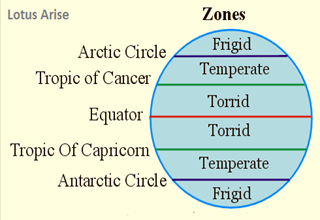
- The three major heat zones of the Earth are:
- Temperate Zone: This is the habitable heat zone of the Earth. There are two temperate zones lie in between in both 23½° to 66½° the hemisphere. These regions have moderate, tolerable temperatures.
- Torrid Zone: This is the hottest zone of the Earth. The region that lies from the Tropic of Cancer (23.5°N), across Equator (0°) to the Tropic of Capricorn (23.5°S) is considered the torrid zone (Tropical Zone). The Sun’s ray falls directly at least once a year.
- Frigid Zone: This is the coldest zone of the Earth. This area lies to the north of the Arctic circle (66.6°N) and to the south of the Antarctic circle (66.5°S) and is permanently frozen. There is no sunlight for most of the months is of the year in this zone.
- These are based on the distance they have from Equator. Frigid Zone
Importance of the Heat Zones
- This division of the Earth into different heat zones helps in understanding the climate changes and to study weather conditions across the world.
|
Mean Annual Temperature Distribution:
|
More Articles