

29th May 2025 (11 Topics)
1
May
2
May
3
May
5
May
6
May
7
May
8
May
9
May
10
May
12
May
13
May
14
May
15
May
16
May
17
May
19
May
20
May
21
May
22
May
23
May
24
May
26
May
27
May
28
May
29
May
30
May
31
May
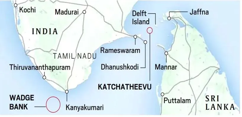
Katchatheevu Island Dispute
Context
Tamil Nadu Chief Minister M.K. Stalin stressed that reclaiming Katchatheevu Island is essential to permanently resolve the hardships faced by the state’s fishermen. He highlighted various welfare initiatives and urged the Union Government to facilitate the release of fishermen arrested in Sri Lankan waters.
Location and Physical Features
- Katchatheevu is a 285-acre uninhabited island located in the Palk Strait between India and Sri Lanka.
- Geographical coordinates:
- Approximately 33 kilometers northeast of Rameswaram (India).
- Approximately 62 kilometers southwest of Jaffna (Sri Lanka).
- The island is unsuitable for permanent habitation due to the absence of potable water.
- The only permanent structure on the island is St. Anthony’s Church, an early 20th-century Catholic shrine, where annual festivals are conducted by Indian and Sri Lankan priests.
Historical Context
- The island is believed to have been formed by volcanic activity in the 14th century.
- Historically, it was under the jurisdiction of the Jaffna Kingdom (Sri Lanka) and later came under the control of the Ramnad Zamindari, administered by the Nayak dynasty of Madurai (India).
- During British colonial rule, it was administered as part of the Madras Presidency.
Legal and Diplomatic Developments
- 1974: Under the Indo-Sri Lankan Maritime Boundary Agreement, India formally recognized Sri Lanka’s sovereignty over Katchatheevu.
- 1976: A subsequent agreement restricted fishing in each other’s Exclusive Economic Zones (EEZs), with Katchatheevu located near the maritime boundary, leading to ambiguity over fishing rights.
- The 1974 agreement allowed Indian fishermen to access the island for non-commercial purposes, such as resting, drying nets, and attending religious festivals, but did not explicitly permit fishing.
Katchatheevu Island DisputeCore Issues in the Dispute
Positions of Key StakeholdersTamil Nadu Government
Union Government of India
The matter is currently pending adjudication before the Supreme Court. |
United Nations Convention on the Law of the Sea (UNCLOS), 1982Overview:
Maritime Zones under UNCLOS:Baseline:
Internal Waters:
Territorial Sea:
Contiguous Zone:
Exclusive Economic Zone (EEZ):
High Seas:
|
PYQ:With reference to the United Nations Convention on the Law of the Sea, consider the following statements:
Which of the statements given above are correct?
|
More Articles