

27th September 2022 (7 Topics)
1
Sep
2
Sep
3
Sep
5
Sep
6
Sep
7
Sep
8
Sep
9
Sep
10
Sep
12
Sep
13
Sep
14
Sep
15
Sep
16
Sep
17
Sep
19
Sep
20
Sep
21
Sep
22
Sep
23
Sep
24
Sep
26
Sep
27
Sep
28
Sep
29
Sep
30
Sep
NavIC: Navigation with Indian Constellation
Context
The Indian government is pushing smartphone makers to enable support for its NavIC navigation system in new devices sold in the country from next year.
About
NaVIC:
- NavIC, or Navigation with Indian Constellation, is an independent stand-alone navigation satellite system developed by the Indian Space Research Organisation (ISRO).
- Built at a cost of $174 million, NavIC was originally approved in 2006 and became operational in 2018.
- NavIC consists of eight satellites and covers the whole of India’s landmass and up to 1,500 km (930 miles) from its boundaries.
- Navigation with Indian Constellation (NavIC), also called the Indian Regional Navigation Satellite System (IRNSS), is considered on par with US-based GPS, Russia's Glonass and Galileo developed by Europe.
- IRNSS will provide two types of services:
- Standard Positioning Service (SPS) which is provided to all the users and
- Restricted Service (RS), which is an encrypted service provided only to the authorised users.
- The IRNSS System is expected to provide a position accuracy of better than 20 m in the primary service area.
- Some applications of IRNSS are:
- Terrestrial, Aerial and Marine Navigation
- Disaster Management
- Vehicle tracking and fleet management
- Integration with mobile phones
- Precise Timing
- Mapping and Geodetic data capture
- Terrestrial navigation aid for hikers and travellers
- Visual and voice navigation for drivers
- Limited Use: Currently, NavIC’s use is limited. It is being used in public vehicle tracking in India, for providing emergency warning alerts to fishermen venturing into the deep sea where there is no terrestrial network connectivity, and for tracking and providing information related to natural disasters.
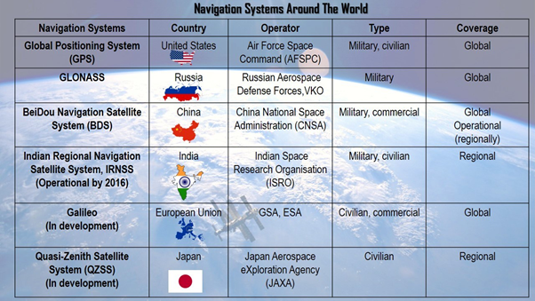
Comparing NaVIC:
- The main difference is the serviceable area covered by these systems.
- GPS caters to users across the globe and its satellites circle the earth twice a day, while NavIC is currently for use in India and adjacent areas.
- Like GPS, there are three more navigation systems that have global coverage – Galileo from the European Union, Russia-owned GLONASS and China’s Beidou.
- QZSS, operated by Japan, is another regional navigation system covering Asia-Oceania region, with a focus on Japan.
Promotion to NaVIC:
- NavIC is conceived with the aim of removing dependence on foreign satellite systems for navigation service requirements, particularly for “strategic sectors.”
- Relying on systems like GPS and GLONASS may not always be reliable, as those are operated by the defence agencies of respective nations and it is possible that civilian services can be degraded or denied.
- NavIC is an indigenous positioning system that is under Indian control. There is no risk of the service being withdrawn or denied in a given situation
More Articles