
Published: 5th Oct, 2019
The Monsoon season of 2019 officially ended with September, but rainfall has continued in several parts of the country which indicates the delayed withdrawal of Monsoon.
Context
The Monsoon season of 2019 officially ended with September, but rainfall has continued in several parts of the country which indicates the delayed withdrawal of Monsoon.
About
Monsoon trends this year:
- After an extremely dry June, which saw a rain deficiency of 33 per cent, the monsoon brought generous rainfall in July, August and September, each subsequent month exceeding the normal by a higher deviation.
- September produced rainfall that was 152 per cent of normal, and this was the second highest rainfall ever recorded in this month. The only higher deviation during September was way back in 1917, when the rainfall was 165 per cent of the then normal for the month.
- August and September together produced 130 per cent of normal rainfall, and this was the highest since 1983. And this was the first time since 1931 that the monsoon ended up producing more than 100 per cent rainfall after having a 30 per cent or more deficiency at the end of the first month.
Monsoon prediction terminology:
- Long Period Average (LPA): It is the average rainfall received by the country as a whole during the south-west monsoon, for a 50-year period. The current LPA is 89 cm, based on the average rainfall over years 1951 and 2000. This acts as a benchmark against which the rainfall in any monsoon season is measured.
- Deficient rainfall: The country is said to have received deficient rainfall if the actual rainfall falls below 90 per cent of LPA.
- Excess rainfall: The country is said to have received excess rainfall if the rainfall is greater than 110 per cent of LPA.
- Normal rainfall: The country is said to have received normal rainfall when the actual rainfall received falls between 96 and 104 per cent of LPA.
Why there is late withdrawal of monsoon?
|
Monsoon prediction terminology:
|
September marks the beginning of the withdrawal of the monsoon. This year, however, withdrawal has seen a record delay. So far, the longest delay happened in 1961 when the withdrawal started on October 1. According to IMD this year the withdrawal is likely to begin only after October 10.
|
The Inter Tropical Convergence Zone (ITCZ): It is a belt of low pressure which circles the Earth generally near the equator where the trade winds of the Northern and Southern Hemispheres come together. It is characterised by convective activity which generates often vigorous thunderstorms over large areas. It is most active over continental land masses by day and relatively less active over the oceans. |
Reasons:
- Last time September produced so much rain, 1917 which happened to be a La Niña year. This year is not a La Nina year but instead of that the rainfall is higher in September. Though there was no La Niña, a similar phenomenon called the Indian Ocean Dipole, could have contributed to the enhanced rainfall.
- During the monsoon season, the Intertropical Convergence Zone (ITCZ) is located over the Indian subcontinent. By September, as the temperature begins to go down, the ITCZ starts moving southwards of the Indian landmass, towards the equator, and further into the southern hemisphere. This year, this process has not yet started.
- In September this year, the northern hemisphere was much warmer than the southern hemisphere, and that could be one reason why the ITCZ has remained longer than usual over the northern hemisphere which resulted into longer stay of monsoon.
- There was a cooling of the eastern equatorial Indian Ocean, below Sumatra, and that could be one of the reasons for this years extended withdrawal of Monsoon.
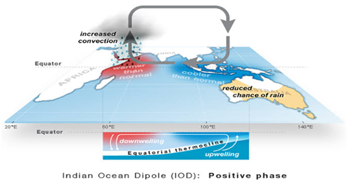
What is Indian Ocean Dipole?
- The Indian Ocean Dipole is a phenomenon similar to the ENSO condition observed in the Pacific Ocean which creates the El Niño and La Niña events.
- The sea surface temperatures in the Indian Ocean gets warmer and cooler than normal, and this deviation influences regional atmospheric and weather patterns i.e. The Indian monsoon.
- While the Pacific Ocean only has an El Niño or a La Niña condition at a time, the Indian Ocean experiences both warm and cold conditions at the same time – that’s why known as dipole.
- One of these poles is located in the Arabian Sea while the other is in the Indian Ocean, south of Indonesia.
- The Indian Ocean Dipole is said to be positive when the western pole is warmer than the eastern one and negative when it is cooler.
- The Indian Ocean Dipole and ENSO are not unrelated. Positive Indian Ocean Dipole events are often associated with El Niño and negative Indian Ocean Dipole with La Niña.
- When the Indian Ocean Dipole and ENSO happen at the same time, the Dipole is known to strengthen the impacts of the ENSO condition.