What's New :
UPSC CSE Result 2023.Download toppers list

What is porosity and permeability?

  • Published
    24th Dec, 2021
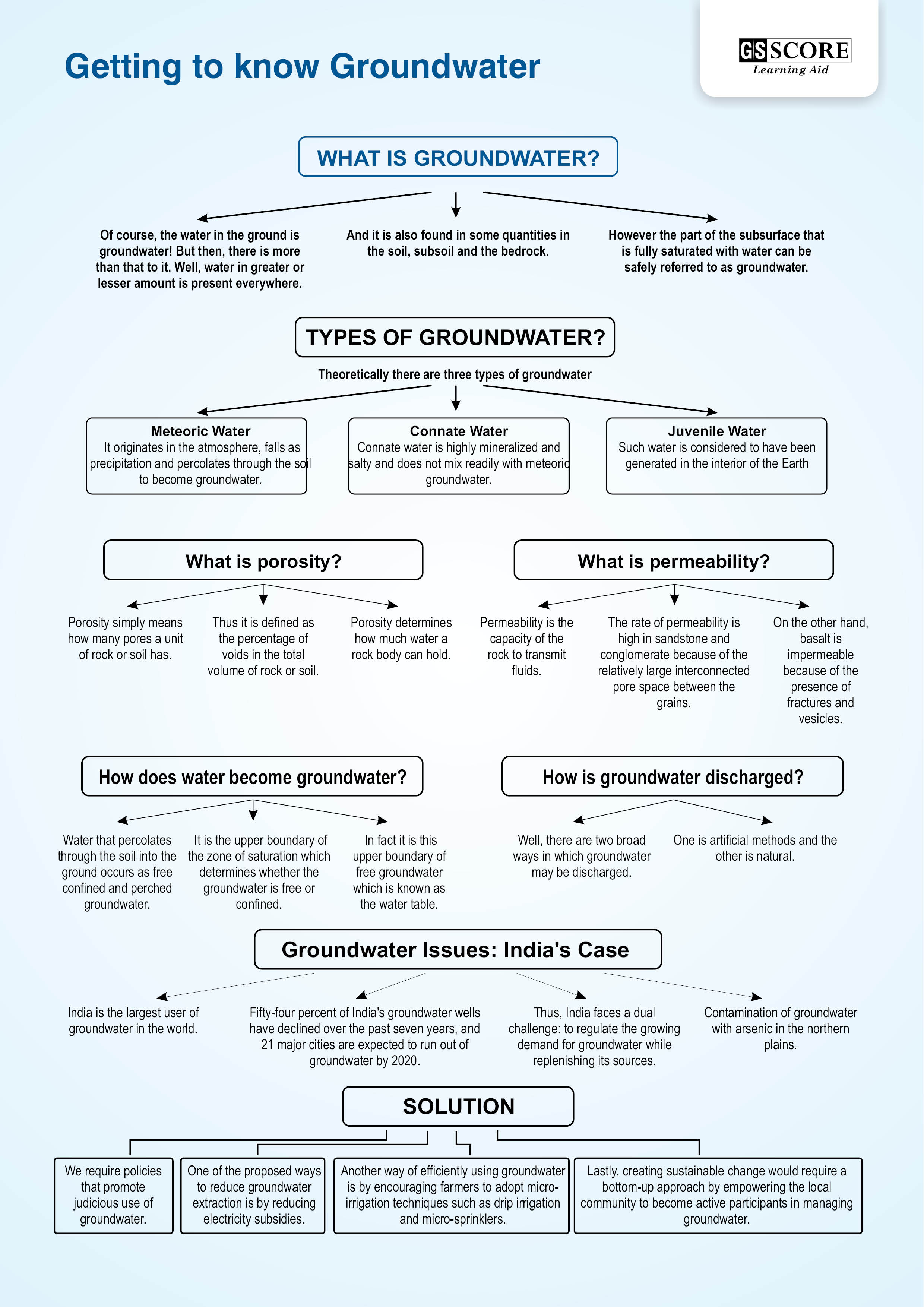
  • Porosity simply means how many pores a unit of rock or soil has.
  • Thus it is defined as the percentage of voids in the total volume of rock or soil.
  • Porosity determines how much water a rock body can hold.
  • The various factors affecting porosity are the shape, arrangement and degree of sorting of the constituent particles and the extent to which changes have occurred as a result of solution, compaction, cementation and faulting.
  • The irregularity of the particle shape has a more important effect on the porosity than the particle size.
  • Permeability is the capacity of the rock to transmit fluids.
  • The rate of permeability is high in sandstone and conglomerate because of the relatively large interconnected pore space between the grains.
  • On the other hand, basalt is impermeable because of the presence of fractures and vesicles.
  • Of course, the water in the ground is groundwater! But then, there is more than that to it. Well, water in greater or lesser amount is present everywhere.
  • And it is also found in some quantities in the soil, subsoil and the bedrock.
  • However the part of the subsurface that is fully saturated with water can be safely referred to as groundwater.

Now, what is fully saturated?

  • You see there are pore spaces in the earth.
  • When these pore spaces are fully filled with water it is known as saturated.
  • The water that fills these spaces may either be of external origin (derived from the atmosphere or surface water) or of internal origin (derived from the interior of the Earth).
  • Well, you might be surprised to note that the interior of the earth does hold some water that is not derived from the atmosphere.
  • We even have a name for this saturated layer that contains a whole lot of water.
  • Yes, it is an aquifer, a Latin word meaning ‘to bear water’.
  • This is the geological formation which saturated with water has been exploited by man for centuries.
  • Did you know this (groundwater) largest single source of water supply amounts to more than 1 million cubic miles compared to the 30, 000 cubic miles of world’s streams, rivers and fresh water lakes and moreover this huge expanse of water is available at depths of less than half-mile in an average.

Theoretically there are three types of groundwater, although you may not be able to access all.

Meteoric Water

  • This constitutes the bulk of what you may exploit.
  • It originates in the atmosphere, falls as precipitation and percolates through the soil to become groundwater.
  • You may have noticed the fluctuation of the water level in wells. Yes, during the rainy season the level goes up while in the summers the level goes down.
  • This is indicative of the fact that groundwater significantly depends upon water from the atmosphere.
  • Another way in which the groundwater may be derived directly from atmospheric moisture is condensation of water vapour from air circulating through the pores and interstices.
  • This is also known as condensational water and is the basic source of replenishment in the arid and semi-arid areas.
  • During summers, the land is warmer than the air in the soil.
  • This results in a difference of pressure between the water vapour in the atmosphere and the soil.
  • The water vapour from the atmosphere penetrates into the rocks as the temperature of the water vapour drops in the cooler soil.
  • A certain amount of water may accumulate this way.
  • A third source is influent seepage from lakes, rivers, oceans and also man-made channels but the importance of this varies with the climate of the area concerned.
  • In fact in humid regions, the groundwater contributes to stream flow by means of effluent seepage, and the gradient of this saturated groundwater more often than not slopes towards the surface water bodies and the oceans.

Connate Water

  • This is the water that is entrapped in the interstices of sedimentary and volcanic rocks at the time of deposition.
  • Connate water is highly mineralized and salty and does not mix readily with meteoric groundwater.
  • Connate water is usually found deep down in the lower layers of the zone of saturation.

Juvenile Water

  • Such water is considered to have been generated in the interior of the Earth.
  • It has consequently travelled to the upper layers of the Earth’s surface for the first time; it is also known as magmatic water.
  • The basic factor that affects the occurrence of groundwater is the nature of voids and interstices.
  • Also their size, shape and distribution in the saturation zone have to be taken into account.
  • If you lived in the desert where no river flowed nearby, you would either have to dig deep for water or collect it when the heavens bless you with a rare shower. The earth too behaves somewhat like that.
  • Of course it doesn’t have the buckets and tanks that you can fashion, but it has rocks deep within the crust that hold the water so that roots of plants may reach it of survive in the leanest of phases.
  • But what man is doing to this fantastic resource of the earth is another story altogether.
  • Well, getting back to the basics, groundwater that percolates through the soil into the ground occurs as free confined and perched groundwater.
  • It the upper boundary of the zone of saturation which determines whether the groundwater is free or confined.
  • In fact it is this upper boundary of free groundwater which is known as the water table.
  • The water table definitely depends on the nature of the groundwater bearing material.
  • In fine textured clay, there will be no clear cut ‘plane’ surface dividing the zone of saturation from the lowest layers of the capillary fringe.
  • In the case of granite, the water table may vary considerably in height over short distances and also may be interrupted in places.
  • While in the case of an open textured rock such as well jointed limestone, the groundwater will move through the interstices to from a more or less horizontal surface.
  • A piezometric surface may be defined as the imaginary surface that coincides with the static level of the water in the aquifer.
  • In the case of confined groundwater, the upper boundary of the water body is formed by an overlying confining stratum in which the spaces are so few and small that groundwater movement is extremely slow.
  • The distinction between free and confined groundwater is made on the basis of hydraulic differences between the flow of groundwater under pressure of a confining layer and the flow of free unconfined groundwater.
  • Perched groundwater refers to a special case in which the confining layer is not continuous over a very large area and is situated at some height above the main confining zone.
  • This confining zone is usually separated by open-textured strata in which the groundwater storage and movement can occur.
  • Well, there are two broad ways in which groundwater may be discharged. One is artificial methods and the other is natural. First the natural method! This includes,
    • evapo-transpiration, particularly in the low lying areas where the water table is close to the ground surface;
    • effluent seepage into surface water bodies, especially where the aquifer flows into a water body such as a lake or a river.
    • leakage through aquicludes in to the adjacent aquifers and
    • spring flow
  • Springs are an interesting feature.
  • The groundwater discharge through springs occurs in areas where the upper surface of the zone of saturation intersects the ground surface.
  • Springs are different from seepage.
  • Springs appear in the form of concentrated discharge of groundwater, a seepage area on the other hand is the slower movement of groundwater to the surface.
  • Springs are classified into several categories.
  • First is the depression spring in which the groundwater flows to the surface from a permeable aquifer.
  • Then there is the contact springs that occurs where the contact plane between a permeable and impermeable rock intersects the ground surface in such a way that the groundwater is deflected to the surface.
  • The contact spring is found at the foot of limestone or chalk escarpment, foot of a scree slope and also along a fault line.
  • Fracture springs occur when a system of interconnected minor faults leads the groundwater to the surface.
  • Another type is the tubular spring whereby groundwater moves through lava tubes or in solution enlarged interstices in limestone.
  • And last but not the least is the spring which arises from hydrostatic pressure.
  • Second is the artificial abstraction.
  • As for artificial abstraction, it is story all of you must be familiar with. It has adversely affected storage in many areas.
  • The groundwater when pumped from wells and boreholes causes a decline in the height of the water surface in the well and results in the formation of a cone of depression around it.
  • Successive abstraction from a large number of wells over a long period of time results in the gradual lowering of the water table or the piezomet.
  • Nature takes care of most of this recharge. But that is not enough anymore. The main components of natural groundwater recharge are
    • infiltration and percolation of part of the total precipitation at the ground surface. The exact proportion actually reaching the water table however depends on the relationship between the rainfall intensity and the infiltration capacity and also the magnitude of the soil moisture deficit;
    • influent seepage through the banks and bed of surface water bodies such as ditches, rivers, lakes and oceans;
    • the underground leakage of water from the adjacent aquicludes and aquifers.
  • But sadly the role of artificial recharge in terms of the total amount of groundwater storage is insignificant but it has grown in some areas of water shortage. The main methods normally used are:
    • water spreading over relatively flat prepared surfaces incorporating a system of shallow basins or ridges and furrows. In the semi-arid areas the natural stream channels may be used during the dry season.
    • the pumping of recharge water down wells and boreholes and Last but not the least are the various techniques that we are discussing under rain water harvesting so that the water table may be replenished and in a few years time.
  • Last but not the least are the various rain water harvesting structures. So assist the replishment of the water table year after year.
  • Various such structures both traditional and modern are in operation at present. However the water renessaince has just began and it will perhaps take years before we begin to realise its benefits.
  • India is the largest user of groundwater in the world. It uses an estimated 230 cubic kilometers of groundwater per year - over a quarter of the global total.
  • More than 60% of irrigated agriculture and 85% of drinking water supplies are dependent on groundwater.
  • Urban residents increasingly rely on groundwater due to unreliable and inadequate municipal water supplies.
  • Groundwater acts a critical buffer against the variability of monsoon rains.
  • Fifty-four percent of India’s groundwater wells have declined over the past seven years, and 21 major cities are expected to run out of groundwater by 2020.
  • Thus, India faces a dual challenge: to regulate the growing demand for groundwater while replenishing its sources. 
  • Subsidies on electricity are thought to play a central role in the Indian groundwater crisis.
  • The vast majority of groundwater pumps are unmetered, and if charged, are billed at a flat, non-volumetric, and highly subsidized tariff .
  • This flat rate is responsible, at least in part, for inefficient usage and excessive withdrawal of groundwater. 
  • In addition, the government encourages farmers to produce water-intensive crops like rice and sugarcane through increased minimum support prices (MSP). 
  • Research indicates that although MSP has led to assured incomes, it has also led to groundwater depletion, income inequality and unsustainable agriculture.
  • On the supply side, performance of state governments has not been satisfactory, with the NITI Aayog Composite Water Management Index (CWMI) report stating that the majority of states have scored less than 50% in the source augmentation of groundwater resource index. 
  • Given this situation, we require policies that promote judicious use of groundwater.
  • Although there are a number of potential interventions in the area of groundwater conservation, there are hardly any rigorous evaluations.
  • In absence of rigorous research, such as randomized evaluations, which can establish the causal impact of an intervention, it is a challenge to identify solutions that are highly effective.
  • However, researchers could draw lessons from existing solutions, and use them to design interventions that could later be rigorously evaluated. 
  • One of the proposed ways to reduce groundwater extraction is by reducing electricity subsidies.
  • An analysis of panel data across 370 districts in India found that a reduction in electricity subsidy was correlated with a decrease in groundwater extraction.
  • On average, a 10% reduction in electricity subsidy generated a 6.7% decrease in groundwater extraction.
  • However, reducing electricity subsidies for farmers could be politically unpopular. 
  • Another way of efficiently using groundwater is by encouraging farmers to adopt micro-irrigation techniques such as drip irrigation and micro-sprinklers.
  • According to the CWMI report, adopting micro-irrigation techniques can save roughly 20% of the groundwater used annually on irrigation in India. A key challenge is to convince farmers to adopt such techniques.
  • A study showed that the adoption of drip irrigation increased in areas where less water-intensive crops such as banana, grapes and coconut were grown.
  • Additionally, the study found that the adoption of drip irrigation was higher in regions where water and labour were scarcer.
  • Thus, it would be prudent for policymakers and researchers to encourage adoption of drip irrigation practices and rigorously evaluate its impact on groundwater levels in such areas. 
  • Lastly, creating sustainable change would require a bottom-up approach by empowering the local community to become active participants in managing groundwater.
  • In line with this, the central government in its 12th five-year plan proposed a policy of participatory groundwater management (PGM), which involves a collaborative approach among government departments, researchers, NGOs and community members.
  • The plan involves training community workers to carry out aquifer mapping and implement innovative ways to use groundwater conservatively with the local community.

Groundwater has helped India overcome food shortage in the 1960s by playing an instrumental role in ushering in the green revolution. However, the NITI Aayog CWMI report is a timely reminder of the need for policymakers and researchers to come together and conduct rigourous evaluations in order to understand what works and what doesn’t work for groundwater conservation. Unless we take urgent measures to avert this crisis, we may find ourselves faced with an environmental catastrophe of our own making.

X

Verifying, please be patient.

Enquire Now