

9th December 2024 (9 Topics)
2
Dec
3
Dec
4
Dec
5
Dec
6
Dec
7
Dec
9
Dec
10
Dec
11
Dec
12
Dec
13
Dec
14
Dec
16
Dec
17
Dec
18
Dec
19
Dec
20
Dec
21
Dec
23
Dec
24
Dec
25
Dec
26
Dec
27
Dec
28
Dec
30
Dec
31
Dec
Declining Low-Altitude Cloud Cover
Context
In 2023, global mean temperatures reached nearly 1.5°C above pre-industrial levels, with new research identifying declining low-altitude cloud cover as a significant contributor to the warming. A study published in Science suggests that 0.2°C of this rise could be attributed to this decline, particularly in regions such as the northern mid-latitude and tropical oceans, including the Atlantic.
The Role of Low-Altitude Clouds in Cooling
- Low-altitude clouds play a crucial role in cooling the planet by reflecting sunlight back into space. However, in 2023, the global cover of these clouds fell by 5%, continuing a decade-long decline of 1.27%.
- This reduction has led to a measurable drop in planetary albedo, the amount of solar radiation that gets reflected away from Earth after interacting with the atmosphere and surface.
- The decline in albedo results in more solar radiation being absorbed by the Earth’s surface, contributing to rising temperatures.
Contribution of Other Factors
- While El Niño and anthropogenic greenhouse gases are primary drivers of the 2023 temperature surge, the study also identified additional factors, such as increased solar activity, volcanic water vapor, and fewer aerosol particles in the atmosphere. However, the researchers noted that even accounting for these variables, 2°C of warming remains unexplained.
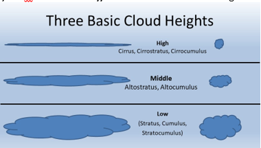
Fact Box: Cloud Types and Classifications
Low-Level Clouds (Base: Below 6,500 ft)
Mid-Level Clouds (Base: 6,500 to 20,000 ft)
High-Level Clouds (Base: Above 20,000 ft)
Other Cloud Types
|
More Articles