NavIC satellite: Why a regional navigation system matters to India
Context
- The Indian Space Research Organisation (ISRO) successfully launched the first of its second-generation navigation satellites.
Key highlights:
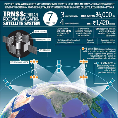
- The heaviest satellite in the Indian Regional Navigation Satellite System (IRNSS) constellation, IRNSS-1I, was launched by a Geosynchronous Satellite Launch Vehicle (GSLV) rocket from Sriharikota.
- Each of the seven satellites in the NavIC constellation were launched by the lighter Polar Satellite Launch Vehicle (PSLV).
- The last IRNSS satellite, IRNSS-1I, was launched in April 2018 to replace an older, partially defunct satellite in the constellation.
What’s new in the second-generation NavIC satellite?
- The second-generation satellite, christened NVS-01, the first of ISRO’s NVS series of payloads is heavier. The features and component of the satellite are:
- Atomic Clock: The satellite will have a Rubidium atomic clock onboard, a significant technology developed by India. “The space-qualified Rubidium atomic clock indigenously developed by Space Application Centre-Ahmedabad is an important technology which only a handful of countries possess,” ISRO said in a statement.
- L1 frequency: L1 signals for better use in wearable devices: The second generation satellites will send signals in a third frequency, L1, besides the L5 and S frequency signals that the existing satellites provide, increasing interoperability with other satellite-based navigation systems.
|
Frequency: The L1 frequency is among the most commonly used in the Global Positioning System (GPS), and will increase the use of the regional navigation system in wearable devices and personal trackers that use low-power, single-frequency chips. |
- Longer mission life: The second-generation satellites will also have a longer mission life of more than 12 years. The existing satellites have a mission life of 10 years.
What is the significance of the atomic clock on board the NVS-01 payload?
- The launch of a replacement satellite in 2018 was due to the failure of existing satellites' onboard atomic clocks.
- This meant that only four IRNSS satellites are able to provide location services, while the other satellites can only be used for messaging services such as disaster warnings and fishing zone messages.
What about the age of the satellites?
- 1A is almost defunct - the failed 1H mission of 2018 was intended to replace this satellite, and all the three oldest satellites in the constellation are close to the end of their 10-year mission lives.
- At least three new satellites must be put into orbit to keep the seven-satellite constellation fully functional.
What practical purpose does the NAvIC constellation serve for users?
- A 2018 report by the Comptroller and Auditor General (CAG) of India said that work on the project started only in March 2017, by which time seven launches had already taken place.
- The receivers have now been developed, and NavIC is in use for projects like public vehicle safety, power grid synchronisation, real-time train information systems, and fishermen’s safety.
- Other initiatives such as common alert protocol based emergency warning, time dissemination, geodetic network, and unmanned aerial vehicles are in the process of adopting NavIC system.
- Some cell phone chipsets such as the ones built by Qualcomm and MediaTek integrated NavIC receivers in 2019.
- The Ministry of Electronics and IT is in talks with smartphone companies to urge them to make their handsets NavIC compatible.
What is the advantage of having a regional navigation system?
- NavIC provides coverage over the Indian landmass and up to a radius of 1,500 km around it, and uses satellites in high geo-stationery orbit.
- NavIC signals come to India at a 90-degree angle, making it easier for them to reach devices located even in congested areas, dense forests, or mountains.
|