

6th August 2022 (6 Topics)
1
Aug
2
Aug
3
Aug
4
Aug
5
Aug
6
Aug
8
Aug
9
Aug
10
Aug
11
Aug
12
Aug
13
Aug
15
Aug
16
Aug
17
Aug
18
Aug
19
Aug
20
Aug
22
Aug
23
Aug
24
Aug
25
Aug
26
Aug
27
Aug
29
Aug
30
Aug
31
Aug
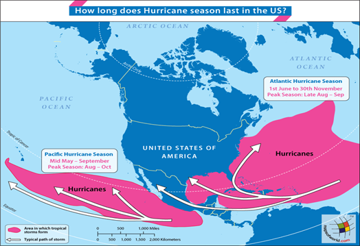
NOAA predicts above-average Atlantic hurricane season
Context
The on-going North Atlantic Ocean hurricane season will be more active than normal from August to November, according to the latest update issued by the United States’ National Oceanic and Atmospheric Administration (NOAA), an American research Institute.
Background
Key-highlights of the predictions
- NOAA predicted a 60 per cent chance of an above-normal Atlantic hurricane season.
- Generally the season of hurricanes began in June, has had no hurricanes till the month of July and only three named storms have formed in the North Atlantic basin.
- The researchers said that there would be 14-20 named storms in the remainder of the season, out of which 6-10 would likely become hurricanes and 3-5 could turn into major hurricanes.
- La Niña aids in the formation, intensification and propagation of hurricanes in the North Atlantic Ocean.
What are Hurricanes?
- Hurricanes are large, swirling storms.
- They can produce winds of 119 kilometres per hour (74 mph) or higher.
- An Atlantic hurricaneor tropical storm is a tropical cyclone that forms in the Atlantic Ocean, primarily between the months of June and November.
Why hurricanes are dangerous?
- Winds from a hurricane can damage buildings and trees. Hurricanes form over warm ocean waters. Sometimes they strike land.
- When a hurricane reaches land, it pushes a wall of ocean water ashore. This wall of water is called a storm surge.
- Heavy rain and storm surge from a hurricane can cause flooding in the nearby island regions.
|
There are five types, or categories, of hurricanes. The scale of categories is called the Saffir-Simpson Hurricane Scale. The categories are based on wind speed.
|
What Are the Parts of a Hurricane?
- Eye: The eye is the "hole" at the centre of the storm. Winds are light in this area. Skies are partly cloudy, and sometimes even clear.
- Eye wall: The eye wall is a ring of thunderstorms. These storms swirl around the eye. The wall is where winds are strongest and rain is heaviest.
- Rain bands: Bands of clouds and rain go far out from a hurricane's eye wall. These bands stretch for hundreds of miles. They contain thunderstorms and sometimes tornadoes.
How Does a Storm Become a Hurricane?
- A hurricane starts out as a tropical disturbance. This is an area over warm ocean waters where rain clouds are building.
- A tropical disturbance sometimes grows into a tropical depression. This is an area of rotating thunderstorms with winds of 62 km/hr (38 mph) or less.
- A tropical depression becomes a tropical storm if its winds reach 63 km/hr (39 mph).
- A tropical storm becomes a hurricane if its winds reach 119 km/hr (74 mph).
What are the Conditions in favour of hurricanes in North Atlantic Ocean?
- There are several atmospheric and oceanic conditions that are still in favour of an active hurricane season.
- La Nina: This includes La Niña conditions, which are favoured to remain in place for the rest of 2022 and could allow the on-going high-activity era conditions to dominate, or slightly enhance hurricane activity.
- Weaker Tropical Trade Winds: In addition to a continued La Niña, weaker tropical Atlantic trade winds, an active west African Monsoon and likely above-normal Atlantic sea-surface temperatures set the stage for an active hurricane season and are reflective of the on-going high-activity era for Atlantic hurricanes.
|
How Are Hurricanes Named?
|
Last major Hurricanes in the North Atlantic Ocean
- 2005 Dennis Katrina Rita Stan Wilma
- Hurricane Santa Ana , 1825
More Articles