

14th April 2025 (12 Topics)
1
Apr
2
Apr
3
Apr
4
Apr
5
Apr
7
Apr
8
Apr
9
Apr
10
Apr
11
Apr
12
Apr
14
Apr
15
Apr
16
Apr
17
Apr
18
Apr
19
Apr
21
Apr
22
Apr
23
Apr
24
Apr
25
Apr
26
Apr
28
Apr
29
Apr
30
Apr
Operation Meghdoot at 41
Context
April 13, 2025, marks 41 years since India launched Operation Meghdoot (1984) and captured the Siachen Glacier.
Strategic Significance of Siachen
- Siachen Glacier is a 76-km long glacier in the Karakoram Range of Ladakh.
- Located at a height of around 20,000 feet in the Karakoram Mountain range, the Siachen Glacier is known as the highest militarised zone around the world.
- It lies between:
- Pakistan-occupied Kashmir (PoK) in the west
- Shaksgam Valley (illegally given to China by Pakistan in 1963) in the north
- Depsang Plains and LAC with China in the east
- Strategic wedge: Siachen sits like a “strategic wedge” between Pakistan and China — giving India control over a crucial triangular zone in the high Himalayas.
- The region controls key high-altitude terrain. It overlooks:
- Gilgit-Baltistan (PoK) on the west
- Depsang Plains and Karakoram Pass on the east
- Shaksgam Valley (ceded to China) on the north
- Indian Army dominates Saltoro Ridge, giving a military advantage over both Pakistan and China.
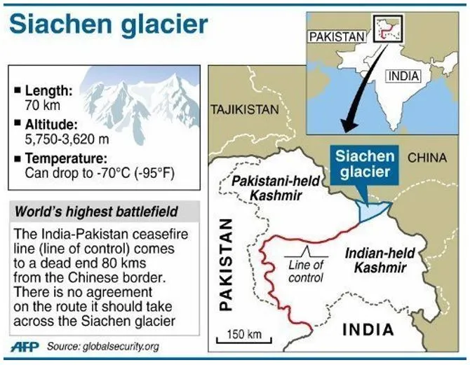
What’s the Dispute?
- After the 1947-48 war, the Karachi Agreement (1949) defined a Ceasefire Line (CFL).
- After the 1971 war, the Shimla Agreement (1972) renamed it Line of Control (LoC).
- BUT — from Point NJ 9842 (a map reference), the LoC is not clearly defined.
- The CFL said it extends “northwards to the glaciers” — but India and Pakistan interpret this differently:
- Pakistan: Wants the line to move northeast to Karakoram Pass (which would give it control of Siachen).
- India: Interprets “northwards” as running along the Saltoro Ridge, which it captured in 1984.
How Did India Capture Siachen? (Operation Meghdoot)
- On April 13, 1984 (Baisakhi Day), under PM Indira Gandhi, India launched Operation Meghdoot.
- Indian troops from 4 Kumaon Regiment were airlifted to Bilafond La (a 17,880 ft mountain pass).
- The Indian Army occupied key passes along the Saltoro Ridge and raised the national flag.
- Pakistan tried to recapture these areas but failed.
- Today, nearly all the aircraft of the Air Force, including Rafale, Su-30MKI, Chinook, Apache, Advanced Light Helicopter (ALH) Mk III and Mk IV, Light Combat Helicopter (LCH) Prachand, MiG-29, Mirage-2000, C-17, C-130 J, IL-76 and An-32 operate in support of Operation Meghdoot.
Why is China Now a Bigger Concern?
- China, not Pakistan, is now seen as the bigger threat around Siachen.
- Chinese PLA could launch a westward military thrust through the Depsang Plains to:
- Cut off the DSDBO Road (India’s lifeline to Karakoram Pass)
- Capture Saser La, which could threaten the Siachen base camp
- China’s Silent Expansion Near PoK: China is present in PoK under the China-Pakistan Economic Corridor (CPEC). Karakoram Highway (part of CPEC) passes close to Siachen. China also sends workers as “dam and road builders” — increasing influence near Indian positions.
- India has deployed tanks, artillery, advanced systems and troops to stop such a move.
- Strategic Infrastructure Nearby: DSDBO Road (255 km) links Leh to Daulat Beg Oldie, near Karakoram Pass. If China cuts this road, Indian access to northern Ladakh is threatened.
More Articles